
A common practice amongst long-distance hikers is to record their journey, day by day. I carried a yellow, waterproof, pocket-sized notebook and planned to fill it with observations: names of people, places, and things; overwrought descriptions of scenery; and insightful depictions of my states of mind. None of that happened.
I couldn’t write in part because I was too tired and also because I couldn’t find words to capture the experience. I wondered what, if anything, I might bring back from my trek to share. Even now, as I think through what I want to post to close out this blog series, I’m unsure of what the experiences mean. Call it trail daze. Different from brain fog, trail daze is more of a trance, a state of awe for moments that cannot be named. One can try, but words won’t do.
I didn’t document my journey except with photographs and daily, GPS-recorded miles covered. Using those, I’ve pieced together the following account of my time on the Trail. I’ll limit words in favor of more pictures in hopes that you may see and hear portions of my trek and enjoy a vicarious take on the journey.
Day One: 12.3 miles; 3,471 feet elevation gain

My first ascent: Devils Fork Gap 
View just feet from my first campsite 
Looking upward after falling backward from exhaustion
From the first ascent of five steps over a stile to the campsite I reached around mid-afternoon, I felt good despite more than six hours of hiking. At first, I had the site to myself; however, an hour later, “Gunn Slinger” — Curtis Gunn, a professional cyclist — arrived and set up camp 15 yards away. He encouraged me to adopt a trail name, a practice I thought reserved for thru-hikers. With some hesitation, I dubbed myself “New Knees” for the right and left knee replacements hammered into place in 2015 and 2016. Gunn Slinger commented that he was happy to be present for my christening. We spoke a bit but mostly allowed one another to enjoy the experience.

Sunset at the end of my first day.
Day Two: 13.2 miles; 2,552 feet elevation gain
The toughest climb of the day occurred at 6:30 am when I tried to stand after climbing from my tent. Yesterday’s exertion left me sore. I wondered if Rigor Mortis had set in; however, I recovered enough before strapping on my pack to take the first steps northbound.

The Way 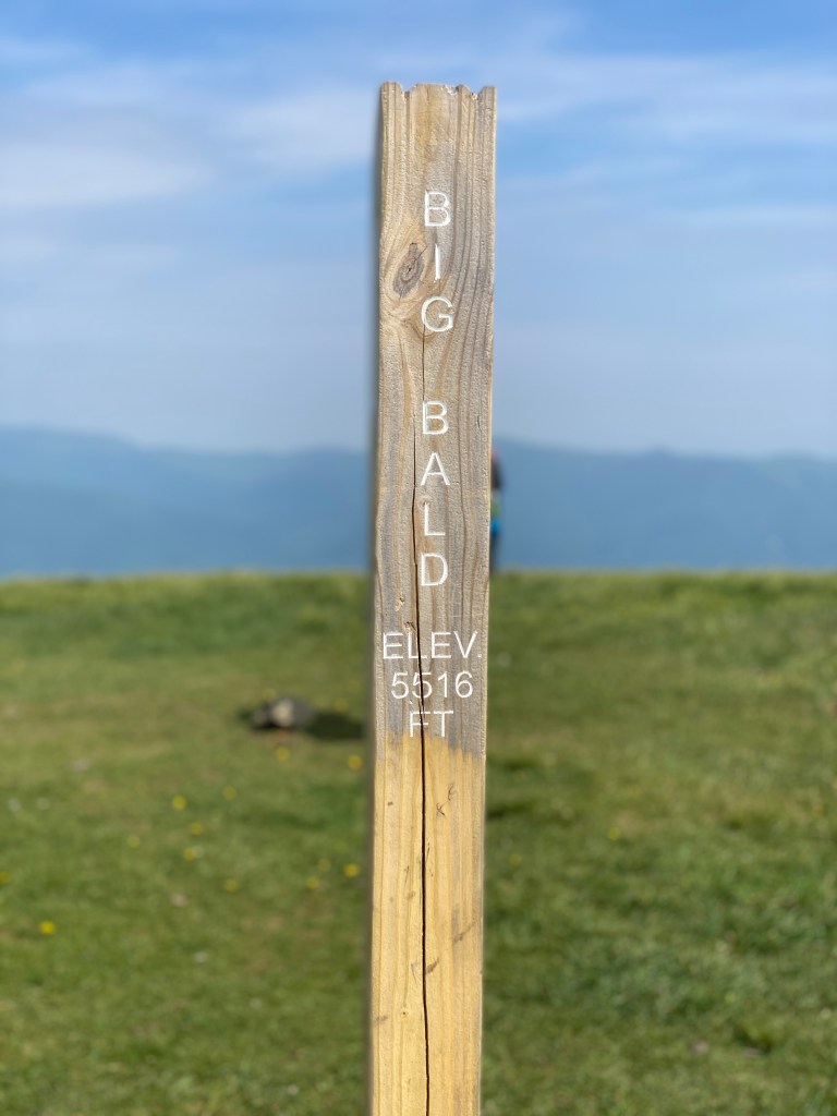
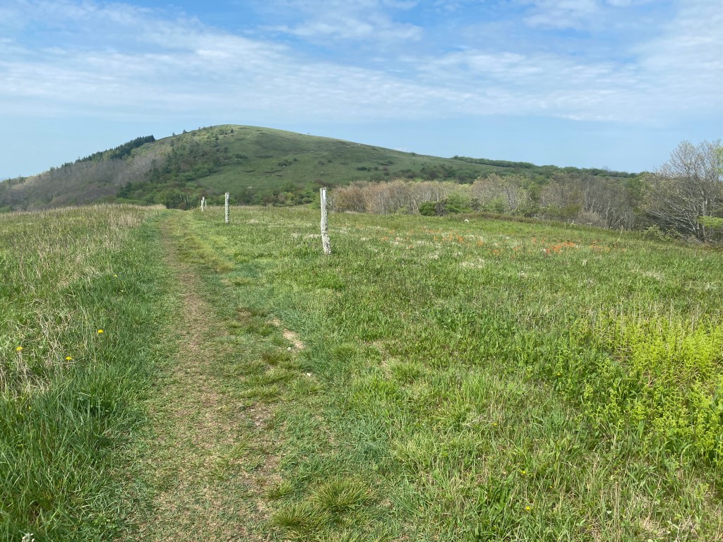
Moving across Big Bald

Atop Big Bald 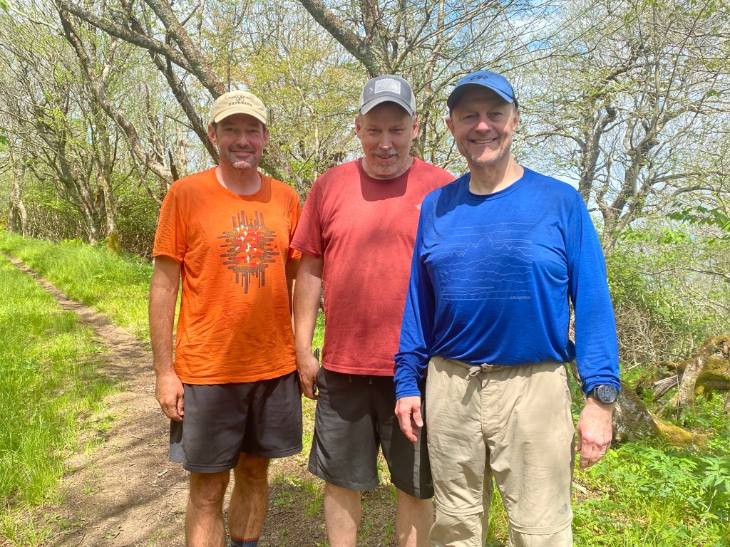
Gunn Slinger and Clay 
Trail Angels: Sonya and Grant
Perhaps the second toughest climb of the day was up to Big Bald (5,516 ft) from which you can see waves of mountains in every direction. The biggest pleasure of the day? Meeting Clay (red shirt) and rejoining Gunn Slinger when we ran into “trail angels” Sonya and Grant, two day-hikers who regularly tote soft drinks, beer, wine, potato chips, oranges, and more to various spots along the trail near their mountain home in Wolf Laurel. This is “trail magic” — gifts for hikers left by benevolent souls. For the first time in years, I enjoyed my first soft drink (Mountain Dew) and a bag of potato chips (sea-salt somethings).
The day ended at Spivey Creek, a wooded site, where I set up camp and enjoyed solitude.

Spivey Creek Campsite
Day Three: 12.7 miles; 1,942 feet elevation gain
I reached the low point of the trip at the start of the third day. It rained hard during the night (enjoy the video below of rain pouring down on the tent in the morning). When I opened the fly, water flooded the tent, drenching my clothes, sleeping bag, and more. It is not pleasant to put on wet clothes, no matter how efficient their “wicking” may be.
That morning, I tore a ligament in my left index finger while lifting my pack. (While it was painful and swollen, the benefit was that I became adept at pinching, buckling, and strapping gear with my thumb and middle finger — a more wholesome use of the middle finger.) With one bar of service, I did what any brave-but-feeling-defeated person would do: I called my spouse to complain.
Unfortunately, the reception was sketchy, and all Lauren heard was “I’m injured” and “Spivey Creek.” This kind soul, this partner of mine for 27 years in marriage, drove 1.5 hours to find me, imagining the worse. Unaware that she was coming, I packed up and trudged onward. Fortunately, I did not go far — perhaps a mile — before I got a call from Lauren who was at Spivey Creek looking for me. We reunited on the trail, and I felt like I should go home with this amazing person who’d driven so far to find me. She asked, “Do you want to finish?” I did. She said, “Carry on” and “I’m proud of you.” Such selflessness.

My drenched pack 
Faceplant 
Rising spirits
The day got better. First, I met my soon-to-be good friend and trail mentor, Faceplant. We ate snacks at the same place, and he told a story of a woman looking for some guy named “Malcolm.” Sheepishly, I identified myself and told the story. “She’s a keeper,” he said.
Second, the solo trek proved uplifting, as all hikes do. A few hikers passed me on their way to Uncle Johnny’s, a hostel popular with thru-hikers. Originally, I thought a hostel would cheapen my experience; however, the allure of drying my clothes and gear proved strong, and my pace quickened up and down the mountains until I came to the final three-mile, 1,500-foot descent to the Nolichucky River.

The Nolichucky River,
1,500 feet below
A closer view 
Rhododendrons in bloom
I had the pleasure of seeing Clay again, as well as spending more time with Faceplant. He provided an invaluable medicated blister bandage — hikers help hikers — and offered useful tips for long-distance trekking: lighten my pack, carry less water, eat more calories, treat blisters immediately, and — should I faceplant — use Loco Tape to repair my glasses. Thank you Faceplant, aka Alan Stuart.

My gravel bed for the night with gear drying out, hung from the rafters beneath an aluminum roof. Hikers spoke of incoming storms and of waiting them out at Uncle Johnny’s Hostel. I didn’t have that luxury.
Day Four: 13.2 miles; 3,573 feet elevation gain
Water seeks the path of least resistance, the lowest point in the terrain, so leaving the Nolichucky involved a wicked ascent from the riverbed. With dry clothes and gear, my pack felt light, and I moved uphill toward the aptly named destination for the day: Beauty Spot. A man who’d driven a road to the 4,420 summit and who was Facetiming his girlfriend when I arrived was kind enough to take my picture after finishing his call.
Climbing Beauty Spot 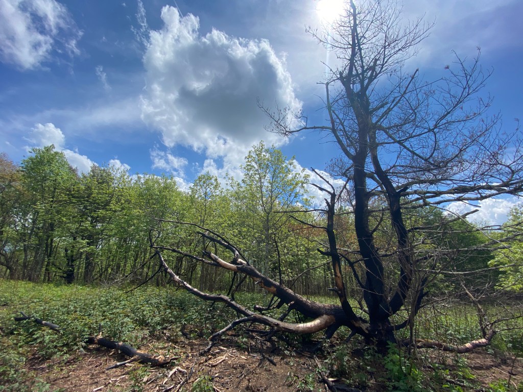
A charred tree on Beauty Spot 
Atop Beauty Spot
I set up camp at Beauty Spot Gap, just a short descent from Beauty Spot, with fellow hikers Double Vision, Clay, and Stealth, whose pit bull “Dozer” was great insurance against bears coming after our food supply. (Inscribed on Dozer’s dog pack: “Yes, I bite.”)

Preparing dinner at Beauty Spot Gap. This was the final afternoon before the monsoon began the following day.
Day Five: 9.9 miles (5.7 miles plus 4.2 miles “slack-packing”); 2,198 feet elevation gain
Double Vision, Clay, and I decided to make a short trek of the day — a bit more than 5.5 miles — to Cherry Gap Shelter given the impending weather. We hiked our own paces — each day, I hiked alone, passing/being passed by at most 4-5 people a day — and each of us arrived at Cherry Gap before the rain.
En route, I met Jonathan, a local Trail Angel, who shared that he had food, soft drinks, and a garbage bag in his pickup “two miles from the shelter.” After setting up camp, I set out to secure a few soft drinks and snacks for the two men and myself. “Two miles” turned out to be three miles, and I never reached Jonathan’s truck because I turned around at 2.8 miles thinking I’d missed a side trail to Jonathan’s truck. While disappointed I didn’t produce any trail magic for Double Vision and Clay, I was grateful to “slack-pack” (hike without a backpack) and to stretch my legs with only my body weight.
The rain set in soon after I returned to the shelter. It wouldn’t stop for the remainder of the trip.
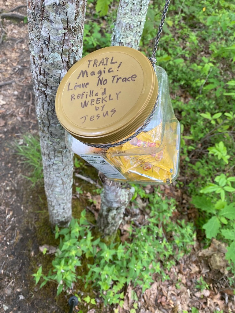
Holy Trail Magic 
Last of the sun 
Jonathan
Day Six: 10.4 miles; 2,208 feet elevation gain
Remember as a child how you would sometimes get caught in the rain and, without care, you’d walk home at a slow pace thoroughly drenched until water overflowed from your shoes? Welcome to Day Six, a ten-mile slog through rain that never let up. Most of the day went through wooded terrain with tree cover so thick that you could hear the rain pummeling the leaves above while only a fraction of the water made it to the forest floor. (See the video below.) At first, I wore my supercalifragilistic Outdoor Research raincoat; however, I got hot in short order and stripped down to a thin, long-sleeve, Capilene shirt.
As I moved up and down various peaks — Little Bald Knob, Piney Bald, Iron Mountain — my body hummed from exertion; however, by the time I reached the Clyde Smith Shelter, five hours after setting out, the temperature had dropped into the lower 50’s, and my hands and upper body felt cold. Sean, Clay, and I arrived separately and took to the shelter. We unrolled sleeping bags, disrobed, and climbed into our sleeping bags to rest and warm up. I cannot remember being so close to hypothermia. It took more than hour to feel as if my body returned to 98.6-degrees.
As the rain grew even harder, more people arrived. Faceplant showed up, and ever cheerful, he brought some light into the otherwise gray space. I met Oomo but was too tired to say, “Huh?” (Oomo: A Tale of Aventures is an early work of Herman Melville, author of that “whale book.”)
Oomo, whose birth name is Pete, spent time writing in his journal, something I admired, especially given the blank pages in my own. We talked only a bit but have since struck up email correspondence about great reading and writing. Perhaps I’ll read Oomo.
As the final day before the ascent of Roan Mountain, I conked out early and only once had to ask some whippersnappers to keep their voices down. It’s the teacher in me.
Below: the gray scene in the Clyde Smith Shelter.
Day Seven: 12.4 miles*; 3,409 feet elevation gain
Today’s mileage was actually 14 miles; I left the shelter without my water filter. A mile northbound from camp, I deliberated going on without it; however, I had only a half liter of Gatorade-powdered water. There was no choice. So it goes on the Trail: momentum and setbacks. It was disappointing to add two miles before the longest, highest ascent of the journey on another chilly, rainy day; however, the obstacle is the way, said Marcus Aurelius (in so many words), and those extra miles added to my satisfaction by day’s end.

Roan Knob loomed over the week as the final push to the end of my journey.
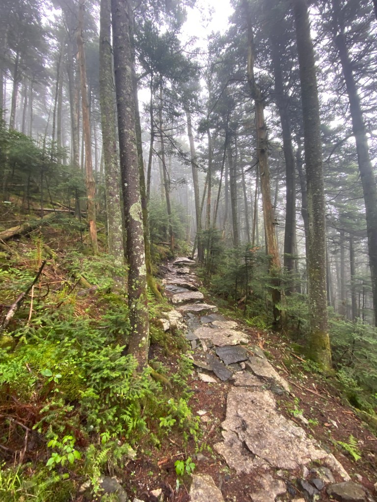
Roan Knob proved less daunting than I’d anticipated because 33 switchbacks (give or take) kept the uphill grade to a reasonable climb. Drawing closer to my journey’s end, a sense of “I made it” set in. After 6-1/2 days of many miles under full load, I grew giddy at the prospect of meeting Lauren, my son Elliott, and our dogs meeting me on the descent from Roan Knob to Carvers Gap.
We coordinated our reunion by phone, and after it became clear that I was going to beat them to the gap, I slowed my pace to enjoy the final scenes and sounds of the woods. The stretch reminded me of hiking Acadia National Park in Maine with the fog and rocks and weather. I realized my hiking had come full circle, as my love of hiking began in Maine.
I hiked this day in a nano-puff vest beneath my full rain jacket, which proved wise because the air cooled to the lower 40’s as the hike ascended above 5,000 feet up to 6,100+ feet. I became grateful for the cold and rain because it kept the number of day hikers to a minimum. Roughly a mile from the finish, I rounded a corner and there was my welcoming party coming up the hill. Spent and delirious with satisfaction, I closed my journey by nearly running down to Carvers Gap.
Climbing Roan as temperatures dropped. 
Full storm-weather gear near the
highest point of the journey.

The time I stepped off the trail after
six nights and seven days.
The journey ends, but the Way continues.
Total miles hiked: 85.7. Total elevation gain: 16,133. Satisfaction: 100 percent.

Thank you for sharing your remarkable journey, Malcolm. I treasure the opportunity to read and feel I have shared just a tad of the intimacy of your thoughts as you accomplished an admirable goal.
Thank you, Tillie, for such a lovely note and for your willingness to look through and read the account. I miss seeing you. It’s been way too long!
Hey Malcolm ~ I copied this blog to read when I can take my time. I did scroll through and your photos are superb! I’ll be with you in spirit the whole way. ~ L
Thanks, Linda — you’re kind to slog through it! Good to hear from you.